Coastal monitoring laboratory using X-band radar network
- Home
- Instruments and Personnel
- Methods and Applications
- Project and Scientific Interests
- Pubblications
The use of X-band radar has received a growing interest thanks to the possibility to use it also as Wave Radar, allowing to measure, with high accuracy and in real time, the wave spectra and the surface current field in a radius up to 5 km. The peculiarities and potentialities of an innovative technology, the Wave Radar, has recently received a growing interest in the field of coastal monitoring thanks to its uses for coastal surveillance and emergency situations. Among the monitoring systems, Wave Radars are emerging for the great advantage of flexibility of use due to their small size, low weight and ease of installation. In particular, the model in use is called 'mobile' because it has the characteristic of being positioned on a pneumatic column mounted on board a towed platform. The nautical radar in question, used for scientific research purposes, works exclusively with short pulses, the transmission is inhibited on land and has a narrow angle of emission directed only towards the sea, radiating it at non-continuous time intervals of a few minutes and only in correspondence of strong swells, in order to allow the acquisition of sufficient data to perform an analysis of the characteristics of wave motion and surface currents in the sea area in front of the site of installation chosen.
The activity described below focuses on the coastal applications of X-band radars, in particular their ability to provide accurate, real-time wavefield measurements at much lower cost and greater accuracy than wave buoys and, therefore, the likelihood of real-time, remote detection of siltation and coastal erosion phenomena.
Coastline changes are an environmental indicator that can identify: a) areas exposed to erosion; b) state-owned assets exposed to risk; and c) priorities for mitigating risk.
The ability to know in real time and with good accuracy the sea surface state allows to deploy a series of applications and tools. The X-band radar system, mounted on fixed stations, near ports or other strategic sites, can be used, up to a distance of 3 nautical miles, to monitor the evolution of the shoreline, generating maps of surface current and the wave field that breaks in generating erosion, and can be a system for the tuning of models for the transport and dissemination of suspended material and the monitoring of river outlets.
INSTRUMENTS AND PERSONNEL
A "wave radar" system consists of:
- 6ft radar antenna for transceiving in the 9300 ÷ 9500 MHz frequency band;
- Acquisition and data conversion system;
- PC for radar control and data processing;
- Software modules devoted to the control and management of the radar unit, of the acquisition interface and for the physical parameters determination that contribute to the definition of the sea state in an area of range up to 1.5 nautical miles from the radar and its storage in a database;
- Software modules dedicated to the generation of surface current maps with high spatial resolution, to the transmission of detected information to database/remote system on TCP/IP protocol with automatic selection of the better transmission channel, to the management and remote control of the system (including the GUI for the visualization of results). The interface for the acquisition and processing of radar signals for the generation of images of the sea surface complies with IEC60945. The Processing Unit is dedicated to post-processing and data storage.
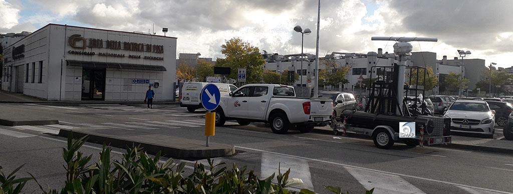
In particular, the model in question is called Mobile because it has the characteristic of being placed on a pneumatic column mounted on board of a platform that can be towed by RSA ITALIA Srl. The pneumatic column can be driven by a single-cylinder 4-stroke gasoline engine generator HONDA GX160 with dimensions (W x D x H) 312 x 362 x 346 mm and dry weight 15.1 kg, displacement 163 cm³, net power 3.6 kW (4.8 HP)/3600 rpm, continuous nominal power 2.5 kW (3.4 HP)/3000 rpm. The fuel tank capacity is 3.1 litres and the estimated fuel consumption at continuous power is 1.4 L/O - 3600 rpm.
Below are some photos of the 'Wave Radar Mobile' system with the detail of the electric generator plugged into the structure. The photo on the left shows the system with the radar antenna mounted on the pneumatic column that is in a vertical position, while the photo on the right shows the system with the column at rest and with minimum space requirement.
")

")
The characteristics of flexibility and mobility of the Radar Mobile system make it unique in the sense that it offers the advantage of allowing coastal monitoring to be carried out ease and fast from any position without the need for a permanent installation, given that the system has a sea view.
Staff
Francesco Raffa (CNR Technologist - Responsible for the Laboratory)
Fabrizio Lirer (CNR Researcher)
Serena Botteghi (CNR Researcher)
Carlo Sardo (CNR Technician)
Lyuba Novi
Contacts
Telephone:
+39 347 1803641 (Francesco Raffa)
+39 050 6212387 (Serena Botteghi)
E-mail:
francesco.raffa@igg.cnr.it
serena.botteghi@igg.cnr.it
lyuba.novi@deltares.nl
The monitoring activity plays a key role in understanding the ongoing phenomena on the shoreline and in evaluating the effects of the actions carried out. Marine radar has always been used to support navigation, allowing the identification of targets at sea. For a better visualization of the targets, the device allows to reduce, through the use of an anti-clutter filter, the return of electromagnetic radiation, called clutter, coming from the sea surface. Only in the last decade the radar devices are used for another application: the monitoring of parameters that characterize the state of the sea. Through the analysis of the clutter signal received by a common X-band radar, it is possible to obtain relevant information on the sea state such as the wavelength, the direction, the period of the dominant waves, the surface currents and the bathymetry of the bottom. Under specific conditions it is also possible to determine the spatial-temporal evolution of the wave motion and monitor, therefore, the height and propagation of the individual waves of the sea surface. This information is useful for the implementation of a range of applications and tools, such as coastal protection and safeguard. Wave Radar in X-band allows to scan the sea surface with high spatial and temporal resolution; this is possible because backscattering from the sea surface, whose intensity may be comparable to that of normal targets, is detected by the radar antenna. The interaction between the electromagnetic waves of the radar and the free surface of the sea can be split into two very different phenomena:
- the reflection of electromagnetic fields according to the laws of optical geometry;
- the dispersion of electromagnetic waves or backscattering, which is the most significant effect whenmeasuring the wave field through common nautical radars in X-band in grazing angle mode, i.e. geometry of acquisition with an angle of view almost parallel to the sea surface. The backscattering effect is caused by the interference of the waves transmitted by the radar with the roughness of the sea surface. This roughness is mainly due to the capillary waves formed by the local wind and other phenomena such as the presence of foam on the sea surface. Therefore, the detection of waves by radar is related to the presence of wind in the area covered by the radar. Experimental results show that a wind of at least 2.5m/s is needed to form ripples on the sea surface, which can give a relatively strong return on the radar video signal.
For this reason, in the wind absence, the system is not able to provide images of the sea surface because the transmitted signal is reflected in a mirror image to the position of the transmitting antenna and not scattered in all directions.
The application aims to support the acquisition of advanced knowledge on the dynamics and/or variations over time of coastal ecosystems in connection with the physical processes that characterize them, to be developed through the experimentation of new monitoring methods in relation to the specific characteristics of the coastal area. With remote detection through the Wave Radar, to be combined with more traditional systems for detailed surveys, important datasets will be provided to test the software, calibrate the systems and compare the results. Changes in the shoreline of the order of magnitude of a few meters can be identified. Data at this spatial-temporal scale are not easily obtained by other remote sensing methods. The use of Wave Radar as a tool to quantify coastal variation at seasonal and event scales in complex hydrodynamic systems is a unique application to monitor areas with dynamic morphology or vulnerable to erosion caused by storm events.
Within the framework of the agreement signed in 2018 with the CNR-ISMAR Naples secondary site, owner of the Wave Radar Mobile, to study and monitor common activities for scientific research purposes, the CNR-IGG is currently using this innovative tool for the first time in Italy to collect monitoring data for the coastal areas of Tuscany. A periodical monitoring activity has been started up on a local scale, in order to identify the areas characterized by the most evident phenomena to be monitored in more detail, such as the San Rossore Park area, between Gombo and Marina di Pisa, Versilia, between Marina di Carrara and Lido di Camaiore, Mazzanta, between Vada and Cecina and the Calafuria area. Since the depth of the bottom, the hydrodynamic characteristics of the sea surface state, the anthropic impact and the spills of material at the river mouths strongly affect the environmental state of the coastal system, the proposed monitoring activity concerns the study of the variations of the coastline and the bathymetry of the shallow waters.
ONGOING ACTIVITIES
Below is the description of the analysis of data acquired by one wave radar in use at the IGG-Pisa Institute: a mobile radar, owned by the CNR of ISMAR-Naples, and installed on a mobile platform, during a sea storm survey carried out in Marina di Pisa (Italy) at coordinates: Lat: 43°39'23.10 "N and Lon: 10°16'52.56 "E on October 2019. The following figure shows the investigated areas with the detail of the X-band radar model SRT Consilium 25KW with 9'' antenna.

The following table shows the operating parameters of the radar system.
Radar parameters | Values |
Peak power | 25 kW |
Antenna length | 2,7 m |
Radar scale | 1,25 NM |
Antenna rotation period (Δt) | 2,4 s |
Spatial image spacing (Δx and Δy) | 4,5 m |
Antenna height | 15 m |
View angular sector | 110° N |
Table 1: Operating parameters of the radar system
As an example, the following figure shows a radar image acquired at 13:35 UTC from Marina di Pisa. The image shows the ships in the vicinity and the radar 'signature' of the sea waves

The radar data analysis algorithms, entirely developed at CNR, allow to estimate, in real-time and with high accuracy, the characteristic parameters of the sea state (significant wave height, direction, period and length of the dominant waves), the surface current range and, under appropriate conditions, the bathymetry of the sea floor up to a distance of 5 Km from the radar. The following images show some examples of the directional spectrum measured during the measurement survey together with the averaged measurements of waves and surface currents.


The spectral images and wave measurements reveal the presence of a dominant wave from approximately 250° to 260°. The wave prediction models provided by the WWMII model produced by ISMAR-CNR and the measurements made by the Gombo buoy of the hydrological weather monitoring service of the Tuscany Region are consistent with the measurements made in the area under study. To verify the strength of the radar measurements obtained during the above survey, it is possible to compare them with the wave forecasts generated by the model and with the tide gauge measurements corresponding to the same day. Below are shown the images of the WWMII wave model of the area under study and the temporal graphs of the height, direction and period of the waves measured by the wavemeter.

The Wave Radar system, in addition to providing wave measurements in terms of characteristic parameters, also reconstructs the wave elevation in space and time with a spatial resolution of a few meters. The following images show a snapshot of the spatial reconstruction of the wave elevation relative to the acquired data. The images, superimposed on the Google map, show the propagation of the dominant wave, coming from OSO, impacting on the coast.

The presence of the coast generates the reflection and refraction of the wave, phenomena associated with the deviation of the propagation trajectory of the waves when they encounter an obstacle in their path. These phenomena are of fundamental importance to understand the effects of the interaction of waves with coastal areas for monitoring the effects of erosion. A coastal area exposed on average to higher wave energy can potentially suffer from more severe natural erosion: a numerical energy calculation model can be used as a preliminary assessment tool to estimate the distribution of the risk of natural erosion along the coast. However, a necessary condition for a correct computation by numerical simulations of that amount of energy is that the inputs are reliable, in this case that they come from real measurements of significant wave heights.
 and sonar (right) bathymetry comparison")
This information, in fact, combined with that of bathymetry of the seabed, provides a complete picture for experts to carry out preventive studies for the construction of new infrastructure but also for more effective beach nourishment or dredging.
SCIENTIFIC INTERESTS
The main scientific interests are linked to the anthropogenic pressure on the coast combined with coastal erosion. Large parts of the shoreline are affected by erosion: although protection works have been carried out, in some parts the coastline is several tens of metres further back. The regional analysis of the average annual rates of change of the shoreline shows that in the period 1984-2005 about half of the Tuscan coast: - 30% have limited variations (between 0.5 and 1.5 m/year), of which almost 18% have been growing; - 10% have seen variations between 1.5 and 3 m/year, equally distributed between stretches in erosion and advancement; - the remaining 6% (4% of the coast originally of sand is now occupied by artificial coast) has greater variations, with a prevalence of erosion phenomena over those of progress (Source: www.regione.toscana.it/difesasuolo: Documento operativo per il recupero e il riequilibrio della fascia costiera, 2016; a cura di: Regione Toscana, Direzione Difesa del Suolo e Protezione Civile, Settore “Genio Civile Valdarno Inferiore e Costa”).
[Translate to English:]
- Michele Punzo, Chiara Lanciano, Daniela Tarallo, Francesco Bianco, Giuseppe Cavuoto, Rosanna De Rosa, Vincenzo Di Fiore, Giuseppe Cianflone, Rocco Dominici, Michele Iavarone, Fabrizio Lirer, Nicola Pelosi, Laura Giordano, Giovanni Ludeno, Antonio Natale, Ennio Marsella, 2016 “Application of X-Band Wave Radar for Coastal Dynamic Analysis: Case Test of Bagnara Calabra (South Tyrrhenian Sea, Italy),” Journal of Sensors, vol. 2016, Article ID 6236925, 9 pages, 2016. https://doi.org/10.1155/2016/6236925.
- Williams, JJ; Esteves, LS and Atkinson, J. X-band radar system to support coastal management decisions [online]. In: Australasian Coasts & Ports 2017: Working with Nature. Barton, ACT: Engineers Australia, PIANC Australia and Institute of Professional Engineers New Zealand, 2017: 1179-1185.
- G. Ludeno, F. Raffa, F. Soldovieri, F. Serafino, 2018. Proof of feasibility of the sea state monitoring from data collected in medium pulse mode by a x-band wave radar system. Remote Sensing 10 (3), 459