GIS, Cartography and Remote Sensing Laboratory
- Home
- Instruments and Personnel
- Methods and Applications
- Projects and Scientific Interests
- Publications
Geographic Information Systems (GIS) play a vital role in those disciplines, particularly in the context of the Earth sciences, which are strongly based on the position, geometry and attributes of spatially referred objects.
When organized in a GIS, spatial data of any kind (geological, geomorphological, hydrogeological, geochemical and environmental, geothermal, etc., as well as administrative, infrastructural, social ...) and origin (scanned, digitized, directly or remotely acquired), can be analyzed and placed in relation to each other. By means of the spatial analysis, mutual coherence and consistency of data can be controlled, both in geographical (topological) and in attributive terms; moreover, new information can be derived and extracted.
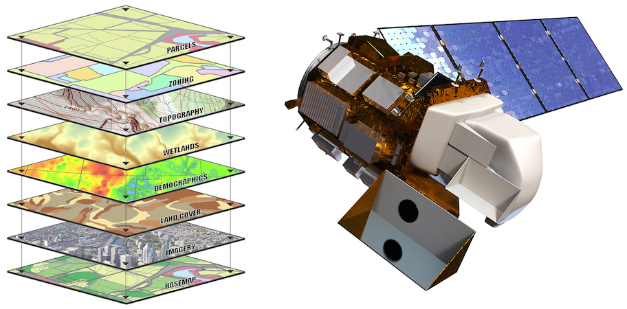
New spatial information, both quantitative and qualitative, are also obtained through the analysis and processing of remote sensing data, mainly recorded from satellite sensors, allowing the detection, classification and monitoring of objects (and phenomena) located on the earth's surface and in the atmosphere through the measurement of the electromagnetic radiation reflected and/or emitted.
The ability to organize the geo-referenced spatial data in overlapping layers makes GIS fundamental not only with respect to the storage, management, analysis and processing of the available information, but also with regard to their visualization and mapping; GIS is an essential tool to synthesize and describe the observed natural systems and their manifestations.
 aquifer system.")
, realized as part of a study on the stability conditions of damaged inhabited centers of the Emilia-Romagna Region.")
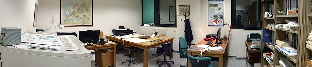
INSTRUMENTS
LabGIS instruments and equipment consist of four workstations, a NAS file server for project data distribution, two large-format printer and an optical stereoscope. The software section, in addition to the main open source applications (QGIS, SNAP, SagaGIS, GRASS, BlenderGIS), consists of many commercial licenses (ESRI ArcGIS Pro and ArcGIS Desktop, Avenza MAPublisher, ENVI, Aquaveo GMS, ArcHydro Groundwater Tools…)
A workstation is available to IGG researchers, trainees and project partners; it is also available a table of large dimensions (250 x 150 cm) for drawing and consultation of maps.
Through the plotters supplied, LabGIS provides also personnel with a large format printing service.
STAFF
Dr. Giulio Masetti (Head Laboratory)
Dr. Giuseppe Cosentino
Dr. Chiara Cavallina
Dr. Giuseppe Turrini
CONTACTS
Phone:
+39 050 6213275
E-mail:
METHODS AND APPLICATIONS
LabGIS operates through the acquisition, interpretation, management and processing of surface and subsoil spatial data, mainly in the fields of geology, geomorphology and characterization of groundwater resources. In this context, activities and related techniques include:
- acquisition, interpretation, management, analysis and processing of surface and subsoil spatial data; geoprocessing, spatial analysis, geostatistics; interpolation and spatialization tecniques; subsoil geological and hydrogeological 3D solid models preparatory to the development of numerical and flow modeling; digital elevation models, morphological and morphometric parameters calculation; data projection and transformation;
- analysis of meteorological-climatic time series and development of routines and iterative tools in Python for the restitution at the basin scale of the daily historical series of precipitation and temperature in the context of the implementation of forecasting models aimed at assessing the vulnerability of the resource to climate change underground water, both in terms of quantity and quality;
- analysis and processing of remote sensing digital imagery and data, multispectral, multiresolution and multiplatform: orthorectification and correction; image enhancing; pansharpening; filtering; object-oriented classification techniques; multitemporal series analysis; change detection; stereo aerial photo analysis and interpretation;
- design, implementation and deployment of project databases: geodatabase design; logical, physical and conceptual data models; topology rules and relations.
- realisation of thematic and seismic microzonation maps; digitization and georeferencing of raster data; map editing; styles definition and symbols libraries construction.
, performed through the analysis and correlation of stratigraphic data (a), the realization of hydrostructural cross-sections (b) and the computation of the main aquifer and aquitard/aquic")
 and top (b) surfaces and thickness (c) of an hydrostructural horizon that was reconstructed as a geovolume.")
 scene: hillshade (left), slope (center) and TPI (Topographic Position Index) Landform (right).")
: (left) natural color (432); (center) false color combination (652, converted from RGB")
, realized as part of a study on the stability conditions of damaged inhabited centers of the Emilia-Romagna Region")
PROJECTS
LabGIS participates in projects aiming at improving knowledge and protection of land and groundwater resources and the production of geological and geothematic databases and maps
- 2023: Geological Map of Italy at scale 1: 50.000 (CARG): geodatabase and print layout of geological sheets no. 274 “Empoli”.
- 2022: Geological Map of Italy at scale 1: 50.000 (CARG): geodatabase and print layout of geological sheets no. 277 “Bibbiena”, 288 “Arezzo” and 320 “Castel del Piano”.
- 2021: Realization of the QGIS MzS Tools Plugin for the seismic microzonation geodatabase and maps
- 2020: Integrated geological researches in the "Palina" mining concession area and surround (Sanpellegrino S.p.A.)
- 2020: IDROBRENTA - Study and modeling of the aquifer system of the Upper Brenta plain
- 2020: Conceptual and numerical modeling of the "Panna" aquifer system (Sanpellegrino S.p.A.)
- 2020: Creation of the manual for the preparation of seismic microzonation cartography according to the Standards of representation and IT archiving and construction of the related standardized symbology (for QGIS and Adobe Illustrator)
- 2019: ASTERIS – Adaptation to Saltwater inTrusion in sEa level Rise Scenarios (Interreg V A Italia Croazia, ID Project n. 10048765)
- 2019: MINIDROSA – Integrated methodologies for the management and protection of the water resource (SMAT – Società Metropolitana Acque Torino S.p.A.)
- 2018: Geological and geomorphological study of the Val di Fine and Volterra-Cerbaie basins (province of Pisa)
- 2018: Geomorphological database of the Tuscany Region (provinces of Livorno and Siena ), scale 1:10.000. Banca dati geomorfologica delle province di Livorno e Siena in scala 1:10.000
- 2018: NEXTDATA – A national system for the retrieval, storage, access and diffusion of environmental and climate data from mountain and marine areas. (National Research Programme, NRP 2011-2013).
- 2017: MONPREVIDRO - Preventive monitoring of the quantitative status of water resources intended for drinking water use based on meteorological, climatological and hydrogeological forecasts
- 2016: Study of the impacts of the climate change on groundwater bodies for drinking water supply purposes in the Turin area (SMAT – Società Metropolitana Acque Torino S.p.A.)
- 2016: FREEWAT (EU Horizon 2020)
- 2016: Implementation, maintenance and management of the Tuscany Region geological databases
- 2013: GEOBASI – The Geochemical database of Tuscany
- 2013: CNR Project “GEOTHERMAL ATLAS”
- 2012: VIGOR, assessment of geothermal potential in convergence regions (interregional operational program)
- 2012: CREA (POR FESR 2017/2013)
- 2011-2016: Advances in knowledge of the Tuscany Region aquifer system. Update and upgrade of the Tuscany Groundwater Bodies geodatabase
- 2011: ZEBU (POR FESR 2017/2013)
- 2009: Identification of the Tuscany groundwater resources protection zones (recharge areas, reserve zones).
- 2008-2010: Stability analysis of Emilia-Romagna Region damaged inhabited centers.
- 2008: Tuscany Region slope stability and superficial deposits cartography
- 2006-2010: Geodatabase of the Tuscany Groundwater Bodies.
- 2005: Thematic geodatabases and maps (geomorphology, permeability, lithotechnics) derived from the Tuscany Geological Map in scale 1:10.000.
MAIN SCIENTIFIC INTERESTS
Aquifer systems stratigraphy and hydrostructure; construction of geological and hydrostructural 3D solid models for the implementation of numerical flow models
Land protection and assessment of the degree of geological hazard through the analysis of deposits, forms and related geomorphological processes related to the slope, fluvial and coastal dynamic in the various geological contexts; stability conditions of damaged inhabited centers.
Implementation of tools and procedures for the thematic cartography of geological risks.


 Right: Thermic anomalies achieved through the application of the RX Anomaly Detection algorithm.")
Right: Thermic anomalies achieved through the application of the RX Anomaly Detection algorithm.
 derived from the geological one.")
Right: Thermic anomalies achieved through the application of the RX Anomaly Detection algorithm.

PUBLICATIONS
- Menichini M, Franceschi L., Raco B., Masetti G., Scozzari A., Doveri M. (2022) – Groundwater Modeling with Process-Based and Data-Driven Approaches in the Context of Climate Change. (https://doi.org/10.3390/w14233956). Water 2022, 14(23), 3956. (ISSN 2073-4441).
- Brussolo E., Palazzi E., von Hardenberg J., Masetti G., Vivaldo G., Previati M., Canone D., Gisolo D., Bevilacqua I., Provenzale A., Ferraris S. (2022) – Aquifer recharge in the Piedmont Alpine zone: historical trends and future scenarios. (https://doi.org/10.5194/hess-26-407-2022). Hydrol. Earth Syst. Sci., 26, 407–427, 2002. (ISSN 2035-8008).
- Marcelli I., Irace I., Fioraso G., Masetti G., Brussolo E., Raco B., Menichini M., Vivaldo G., Doveri M., Pispico R., Cozzula S. (2022) – The Subsurface Database of the Torino Area (Western Po Plain): From the Design of the Conceptual Scheme to 3D Modeling. (DOI 10.1007/978-3-030-94426-1_9). In: E. Borgogno-Mondino and P. Zamperlin (Eds.), ASITA 2021, CCIS 1507, Geomatics and Geospatial Technologies. Proceedings of the 24th Italian Conference, ASITA 2021, pp. 106-119. Springer Nature Switzerland AG 2022 (ISBN 978-3-030-94425-4).
- Raco B., Vivaldo G., Doveri M., Menichini M., Masetti G., Battaglini R., Irace A., Fioraso G., Marcelli I., Brussolo E. (2021) – Geochemical, geostatistical and time series analysis techniques as a tool to achieve the Water Framework Directive goals: An example from Piedmont region (NW Italy). (https://doi.org/10.1016/j.gexplo.2021.106832). Journal of Geochemical Exploration, Vol. 229, October 2021, 106832. 20 pp. (ISSN 0375-6742).
- Vignaroli G., Mancini M., Bucci F., Cardinali M., Cavinato G.P., Moscatelli M., Putignano M.L., Santangelo M., Ardizzone F., Cosentino G., Di Salvo C., Fiorucci F., Gaudiosi I., Peronace E., Polpetta F., Reichenbach P., Simionato M., Stigliano F. (2019). Geology of the central part of the Amatrice Basin (Central Apennines, Italy). Journal of Maps, vol. 15, p. 193-202, ISSN: 1744-5647, doi: doi.org/10.1080/17445647.2019.1570877
- Doveri M., Irace A., Lelli M., Masetti G., Menichini M., Nisi B., Raco B. (2020) - Dynamics of groundwater systems. In: A. Donato and E. Palazzi (eds.), Climate and environmental changes in the Italian mountains. Progetto Nazionale di Interesse Strategico NEXTDATA, Volume Finale, Capitolo 7.3. (ISBN 9788879580489)
- Masetti G., Da Prato S., Menichini M, et al. (2017) – Dal modello concettuale al modello numerico: il caso di studio del sistema acquifero di Follonica (GR, Toscana meridionale). (DOI: 10.3301/ROL.2017.13). Rend. Online, Soc. Geol. It., Vol. 42 (2017), pp-54-58, 3 figs. (ISSN 2035-8008).
- Masetti G. (2016) – Banca Dati dei Corpi Idrici Sotterranei della Regione Toscana. Modello logico e fisico dei dati. Dizionario degli attributi delle classi. Rapporto tecnico (Convenzione Igg/Lamma del 07/02/2014), Rep. Biblioteca Cnr-Igg n. 11176, marzo 2016, 18 pp.
- Masetti G., Da Prato S. (2016) – Banca Dati Sottosuolo della Regione Toscana. Modello logico e fisico dei dati. Dizionario degli attributi delle classi. Rapporto tecnico (Convenzione Igg/Lamma del 07/02/2014), Rep. Biblioteca Cnr-Igg n. 11177, marzo 2016, 13 pp.
- Menichini M., Da Prato S., Doveri M., Ellero A., Lelli M., Masetti G., Nisi B., Raco B. (2015) – An integrated methodology to define Protection Zones for groundwater-based drinking water sources: an example from the Tuscany Region, Italy. (DOI 10.7343/AS-102-15-0129) Acque Sotterranee – Italian Journal of Groundwater, Vol. 4, n. 139, 21-27. (ISSN 1828-454X).
- Raco B., Buccianti A., Corongiu M., Lavorini G., Macera P., Manetti F., Mari R., Masetti G., Menichetti S., Nisi B., Protano G., Romanelli S. (2015) – GEOBASI: The geochemical Database of Tuscany Region (Italy). (DOI 10.7343/AS-100-15-027) Acque Sotterranee – Italian Journal of Groundwater, Vol. 4, n. 139, 7-18. (ISSN 1828-454X).
- Autori vari (2014) – VIGOR: Sviluppo geotermico nelle Regioni della Convergenza. Progetto VIGOR – Valutazione del Potenziale Geotermico nelle Regioni della Convergenza, POI Energie Rinnovabili e Risparmio Energetico 2007-2013, CNR-IGG (ISBN: 9788879580113).
- Masetti G., Ottria G., Ghiselli F., Ambrogio A., Rossi G., Zanolini L. (2013) – Multidisciplinary Study of the Torrio Landslide (Northern Apennines, Italy) in: C. Margottini et al. (eds.), Landslide Science and Practice, Vol. 1, DOI 10.1007/978-3-642-31325-7_23, # Springer-Verlag Berlin Heidelberg 2013.
- Doveri M., Nisi B., Cerrina Feroni A., Ellero A., Menichini M., Lelli M., Masetti G., Da Prato S., Principe C., Raco B. (2012) - Geological, hydrodynamic and geochemical features of the volcanic aquifer of Mt. Amiata (Tuscany, Central Italy): an overview. Acta Vulcanologica, 23 (1-2), 2011 / 24 (1-2), 2012, 51-72. (ISSN 1121-9114)
- Raco B., Cerrina Feroni A., Da Prato S., Doveri M., Ellero A., Lelli M., Masetti G., Nisi B., Marini L. (2011) - Environmental Security Issues Related to Impacts of Anthropogenic Activities on Groundwater: Examples from the Real World. In: A. Scozzari A., El Mansouri B. (edited by): Water Security in the Mediterranean Region. An international evaluation of management, control and governance approaches. NATO Science for Peace and Security Series C: Environmental Security, DOI 10.1007/978-94-007-1623-0_11, © Springer Science+Business Media B.V. 11, 153-162. (ISBN 978-94-007-1622-3)
- Cerrina Feroni A., Da Prato S., Doveri M., Ellero A., Lelli M., Marini L., Masetti G., Nisi B. & Raco B. (2010) – Corpi idrici sotterranei della Val di Cecina. Editore Manetti P., Memorie descrittive della Carta Geologica d’Italia, vol. LXXXIX, pp. 99. (ISSN 0536-0242; ISBN 978-88-240-2962-9)
- Cerrina Feroni A., Ellero A., Masetti G., Ottria G., Pardini E. (2008) – I Corpi Idrici Sotterranei Significativi della Regione Toscana (DGRT 225/2003). Inquadramento regionale. Perimetrazione e ricostruzione. Prospettive e sviluppi. Regione Toscana, Consiglio Nazionale delle Ricerche – Istituto di Geoscienze e Georisorse, Consorzio LaMMa. Centro stampa Giunta Regione Toscana (pp. 134).