
The laboratory is housed in the IGG Pisa headquarter.
The Laboratory
Geophysics is a science that applies the principles of physics to the study of the Earth. Exploratory geophysics and applied geophysics use quantitative methods to investigate the Earth's interior and its physical properties. Measurements taken at the surface can reveal how the physical properties of the Earth's interior vary in space (and possibly also in time).
Covering all aspects of Earth's physics, geophysics is a fundamental pillar in supporting the needs of civil society. Research conducted at the IGG's Exploratory and Applied Geophysics Laboratory focuses on the exploration of georesources, primarily (but not limited to) geothermal and hydrogeological resources. Researchers at the laboratory have been active since 1990 in exploring tectonically complex areas for crustal, tectonic, volcanological, and geothermal studies.
The laboratory is equipped to perform geoelectric and electromagnetic measurements using recently acquired cutting-edge geophysical instrumentation. The laboratory also has the most up-to-date tools for processing, analyzing, and inverting geophysical data.
The laboratory's researchers conduct research to develop probabilistic algorithms based on computational intelligence for solving the geophysical inverse problem, including when combined and/or constrained by external geological information. Research conducted in the laboratory also focuses on the 3D integration of different data sources (well, geological, geophysical) to unravel the complexity of subsurface systems.

Instruments
The Exploration and Applied Geophysics Laboratory was recently renovated with the purchase of new equipment. The Laboratory boasts state-of-the-art instruments for measuring geoelectric and magnetotelluric data:
Broadband magnetotelluric (MT) instrumentation (0.0001 Hz – 1000 Hz):
Zonge system. A 32-bit, high-resolution, multi-channel receiving system for recording the two electric field components (Ex, Ey) and the three magnetic field components (Hx, Hy, Hz). Broadband MT data and audio spectrum (AMT) can be acquired for studying subsurface resistivity.
Components:
- 3 wideband ZEN HighRes receivers (0.0001 Hz to 1000 Hz). The receiver can acquire 6 synchronized channels with different sampling rates from 256 Hz to 4096 Hz. Each channel has 8 GB of storage space, allowing continuous recording for several days.
- 8 ANT/4 magnetometers produced by ZONGE.
- Series of non-polarizable electrodes of various types: Pb-PbCl (Wolf) and Ag/AgCl (Stelth)
- Miscellaneous accessories

Instrumentation for electrical resistivity tomography (ERT), spontaneous potential (SP) and induced polarization (IP) measurements:
ABEM System. A stand-alone, multichannel system for transmitting electric current and accurately measuring electric potential, induced polarization, and resistivity measurements.
Components:
- 1 Terrameter LS 2, 10 channels (up to 12), 48 electrodes (up to 81). Maximum output voltage 600 V, maximum output current 2500 mA, maximum output power 250 W.
- 2 multicore cables with 24 takeouts and 10 m inter-electrode spacing (480 m total length)
- Set of steel electrodes

Il laboratorio dispone anche strumentazioni molto vecchie, alcune delle quali conservate nell’angolo storico del laboratorio (ad esempio il sistema MT Phoenix V5) mentre altri strumenti saranno valutate per un possibile recupero.
Strumentazione ibrida audio magnetotellurica naturale (AMT) e a sorgente controllata (CSAMT) (0.1 Hz – 100 kHz):
Sistema Stratagem (Geometrics). La tecnica “Stratagem” a sorgente ibrida sfrutta una sorgente ibrida del segnale da una combinazione del segnale naturale MT e un segnale trasmesso artificialmente per lo studio della resistività elettrica di sottosuolo.
- 1 STRATAGEM transmitter with a vertical antenna circuit
- 1 STRATAGEM receiver
- High and low frequency magnetometers
Low frequency magnetotelluric (MT) instrumentation (0.0001 Hz – 0.03 Hz):
- 2 x 24-bit NIMS (Narod Intelligent Magnetotelluric Systems) receivers
- 3 magnetometers (3-component fluxgate)
Instrumentation for gravimetric measurements:
- 1 Gravimeter
Data analysis and modeling tools:
- Laptop for in-situ processing of MT data
- High-performance desktop computers for geophysical and geological data processing and modeling
- Access to the CNR-IGG high-performance server for computing
Software
- 3 licenses for Winglink (Schlumberger) for data processing, 1D/2D modeling and 3D direct modeling of geophysical data
- 1 license for Petrel (Schlumberger) for 3D geological modeling and data integration (managed by CNR-IGAG)
- 1 license for Zonge software for data processing, 1D/2D modeling
- 1 license for MODEM (ModEM-Geophysics) for 3D inversion of magnetotelluric data
- Various open-source software for processing and modeling geophysical data
- In-house software developed by the laboratory's researchers for the analysis and modeling (including joint inversion) of geophysical data based on computational intelligence

Staff and Contacts
The laboratory staff is composed of:
- Dr. Alessandro Santilano (Laboratory Manager)
- Dr. Adele Manzella
- Dr. Assunta Donato
Contacts:
Phones
- +39 050 6213417 (Laboratory)
- 39 3403562904 (Dr. Alessandro Santilano)
- +39 050 6212392 (Dr. Adele Manzella)
email:
- alessandro.santilano@igg.cnr.it
- adele.manzella@igg.cnr.it
- assunta.donato@igg.cnr.it
Methods and Applications
Magnetotellurics
Magnetotellurics (MT) is a passive electromagnetic geophysical method used to investigate the electrical resistivity of the subsurface. The method is based on the measurement of natural electric and magnetic fields on the Earth's surface with frequencies of 10 Hz and 10 Hz. The energy source corresponds to natural electromagnetic waves generated in the atmosphere and magnetosphere by various physical processes, such as: i) the Schumann resonance of lightning discharges for the higher frequencies and ii) the interaction between the Earth's magnetosphere and the solar wind for the lower frequencies.
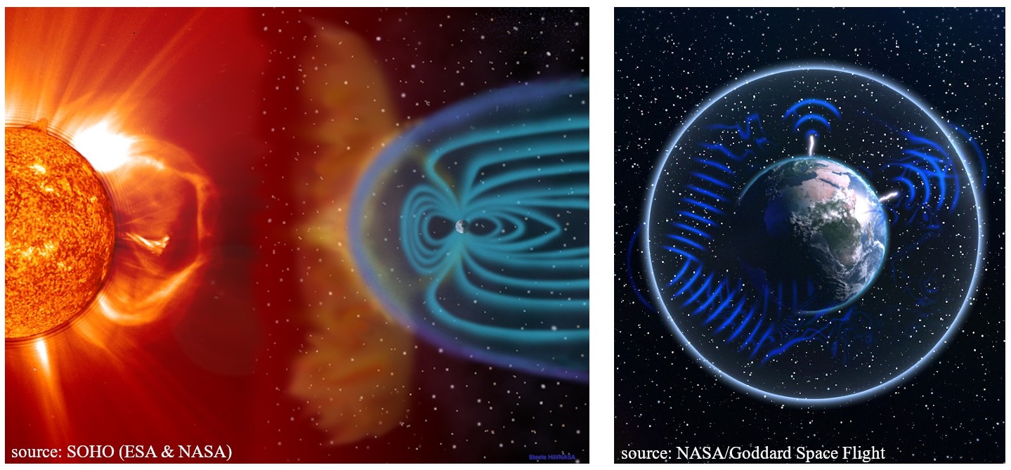
Radio-magnetotelluric (RMT), audio-magnetotelluric (AMT), broadband magnetotelluric (BBMT), and long-period magnetotelluric (LMT) methods differ in the frequencies they measure. Since the MT method is based on the electromagnetic processes of induction and diffusion, the depth of investigation depends on the measured frequencies (and the subsurface resistivity) according to the skin effect. The higher the measured frequency, the shallower the depth of investigation.
The method is capable of investigating resistivity from tens of meters to hundreds of kilometers. The AMT method is generally limited to a depth of about 1-3 km.
The controlled-source magnetotelluric (CSMT) method is based on the same theoretical basis as the MT method and uses an artificial transmitter of the electromagnetic signal. The method improves the signal-to-noise ratio when anthropogenic noise or a weak natural signal may be present.
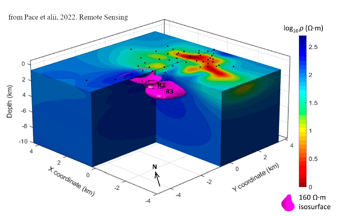
Simultaneous measurements of the orthogonal components of the electric and magnetic fields at the surface provide the data to calculate the transfer function (impedance) as a function of frequency. The impedance, in turn, is used to reconstruct subsurface resistivity models.
At each MT site, five synchronized measurements are recorded: the electric field in two directions, the magnetic field in the same directions and in the vertical direction; the horizontal directions are orthogonal. A typical MT data acquisition station consists of two pairs of electrodes arranged as orthogonal dipoles with a length between 50 and 100 meters and three magnetometers, also arranged orthogonally (two horizontal and one vertical).

The magnetotelluric method has no environmental impact, even visually, as the sensors are buried underground. A study area is explored using multiple measurement sites, whose locations are chosen to uniformly cover the area, taking care to avoid difficult-to-access or noisy sites.
Among the various fields of application of the magnetotelluric prospecting method, CNR-IGG researchers have mainly worked on:
- Geothermal exploration to study fluid circulation pathways and heat sources in geothermal systems
- Volcanological studies, to study the depth and volume of magma chambers in active Italian volcanoes (Vesuvius and Etna)
- Hydrogeological exploration
- Deep crustal exploration
Geoelettrica
The geoelectric method is one of the oldest and most widely used methods for geophysical exploration. The first pioneering applications were conducted almost simultaneously by Conrad Schlumberger and Frank Wenner in the early 1900s.
The method is widely used for georesource exploration, and for environmental, civil engineering, and archaeological studies. From the early days of the methodology until the 1980s, the 1D investigation method was widely used, but was gradually replaced by multichannel and multielectrode acquisition systems and multidimensional modeling algorithms.
Recent systems use automatic data acquisition protocols to obtain 2D and 3D tomographic reconstructions of the subsurface.
This technique is more properly called: electrical resistivity tomography (ERT).
The theory is based on Ohm's law which relates the (unknown) electrical resistivity to the current and the electric potential.
A typical acquisition involves injecting current into the ground through two current electrodes AB (usually metal stakes), measuring the voltage difference at the two potential electrodes MN.
A multi-electrode georesistivity meter automatically, after specific programming, selects the two pairs of electrodes for each measurement, allowing the use of any acquisition configuration.
Measurements with different spacing and different positions of the electrode pairs can obtain 2D or 3D models of the subsurface.
As a first approximation, the investigation depth is approximately 1/5 to 1/6 of the total length of the array.
Among the various fields of application of geoelectric prospecting, CNR-IGG researchers have worked in particular on:
- Geothermal exploration to investigate fluid circulation pathways
- Hydrogeological studies (a campaign in the Arctic environment will be conducted soon)

Inverse Modeling
In geophysics, a thorough understanding of the physical principles (direct operator) behind the prospecting method allows for the correlation of measured data with Earth model parameters. The inverse problem involves defining the model parameters "m" given a set of observed data "d." Solving the inverse problem allows for an estimate of the subsurface electrical resistivity from the analysis of surface-measured data (magnetotelluric, geoelectric, etc.). The problem is generally ill-posed (e.g., for the MT method) due to its instability and requires significant computational resources.
Methods for solving the inverse problem can be classified as deterministic and probabilistic. Deterministic methods are the conventional approach for estimating resistivity models.
Since the MT response is particularly influenced by the dimensionality of the measured impedance tensor, deterministic schemes for 1D-2D and 3D inversion are available in the literature, with 3D inversion being the subject of the most recent scientific research.
In general, model parameters are calculated by minimizing an objective function using differential operators. The procedure can reach a local minimum, depending also on the distance of the initial model from the global minimum.
In the Exploration and Applied Geophysics Laboratory, advanced codes are used for the inversion of MT and geoelectric data in 1D-2D-3D.
On the contrary, the probabilistic approach is less conventional and still a matter of research.
The probabilistic method does not require differential operators, but the model space is sampled randomly or based on some kind of strategy.
In the probabilistic method, many terrain models are proposed and theoretical data are compared with observed data. The minimization function is directly calculated to obtain the best model. The philosophy of the probabilistic approach, which can be considered an optimization procedure, is to explore larger model search spaces to seek a global solution to the problem.
Researchers at the Laboratory of Exploration and Applied Geophysics, in collaboration with other partners, are developing algorithms based on Computational Intelligence to solve the inverse geophysical problem, including joint problems.
Scientific Projects and Interests
The Laboratory of Exploration and Applied Geophysics has been involved in numerous scientific projects and collaborations with many national and international universities and research centers.
Recent projects:
- ICEtoFLUX (Programma di Ricerche in Artico “PRA”, 2022-2024): “HydrologIcal changes in ArctiC Environments and water-driven biogeochemical FLUXes”
- GECO (Progetto EU-H2020, 2018-2022): “Geothermal Emission Control”
- GEMEX (Progetto EU-H2020, 2016-2020): “Cooperation in Geothermal energy research Europe-Mexico for development of Enhanced Geothermal Systems and Superhot Geothermal Systems”
- IMAGE (Progetto EU-FP7, 2013-2017): “Integrated Methods for Advanced Geothermal Exploration”
- “Geothermal Atlas of Southern Italy” (CNR Project for Southern Italy, 2011-2016)
- VIGOR (POI-FESR Project, 2010-2014): “Evaluation of the Geothermal Potential of the Convergence Regions”
- I-GET (Progetto EU-FP6 2005-2009): “Integrated Geophysical Exploration Technologies”
- Si.Ri.Pro (Progetto PON 2004-2010): “SIsmica a RIflessione PROfonda, Metodologie integrate per l’esplorazione geofisica avanzata lungo un transetto crostale, Sicilia (Deep Reflection Seismic, Integrated methodologies for advanced geophysical exploration along a crustal transect in Sicily)”
- Progetto INTAS EU Project (2004-2006): “Three-dimension electromagnetic and thermal tomography of the active crustal zones”
Collaborations and case studies (with or without fieldwork):
- Geothermal studies in Italy; Slovakia; Iceland; Ethiopia; Mexico; Tibet; Australia; Sri Lanka
- Hydrogeological studies: Svalbard (Arctic, coming soon); Pianosa Island; Equi Terme; Monte Amiata (Italy)
- Magnetotelluric study for the environmental impact assessment of the Cafaggiolo Medici Residence (Barberino di Mugello, Florence)
- Crustal studies: MT along profiles from the CROP project (Italy); Czech Republic; Antarctica
- Volcanic studies in collaboration with INGV (Vesuvius and Etna)
Scientific Interests:
- Geothermal, crustal and volcanological studies
- Development of Artificial Intelligence-based algorithms for geophysical modeling
- Integrated modeling for georesource exploration
Publications
- Pace, F., Marti, A., Queralt, P., Santilano, A., Manzella, A., Ledo, J., Godio, A., 2022. Three-dimensional magnetotelluric characterization of the Travale geothermal field (Italy). Remote Sens. 2022, 14(3), 542
- Santilano, A., Godio, A., Manzella, A. 2018. Particle swarm optimization for simultaneous analysis of magnetotelluric and time-domain electromagnetic data. Geophysics, 83 (3), E151-E159
- Godio, A. and Santilano, A. 2018. On the optimization of electromagnetic geophysical data: application of the PSO algorithm. Journal of Applied Geophysics 148, 163-174
- Santilano, A., Donato, A., Galgaro, A., Montanari, D., Menghini, A., Viezzoli, A., Di Sipio, E., Destro, E., Manzella, A. 2016. An integrated 3D approach to assess the geothermal heat-exchange potential: the case study of western Sicily (southern Italy). Renewable Energy 97 (2016) 611-624
- Santilano, A., Manzella, A., Gianelli, G., Donato, A., Gola, G., Nardini, I., Trumpy, E., Botteghi, S., 2015. Convective, Intrusive Geothermal Plays: what about tectonics? Geothermal energy Science, 3, 51-59
- Molli, G., Doveri, M., Manzella, A., Bonini, L., Botti, F., Menichini, M., Montanari, D., Trumpy, E., Ungari, A., Vaselli, L., 2015 Surface-subsurface structural architecture and groundwater flow of the Equi Terme hydrothermal area, northern Tuscany Italy. Ital. J. Geosci., Vol. 134, No. 3, pp. 442-457
- Spichak V. and Manzella A., 2009. Electromagnetic sounding of geothermal zones. Journal of Applied Geophysics, 68, 459-478
- Armadillo E., Bozzo E., Caneva G., Manzella A., Ranieri G. 2007. Imaging deep and shallow structures by electromagnetic soundings moving from the Transantarctic Mountains to the Wilkes Subglacial Basin. Terra Antartica Reports. Issue 13, Pages 65-74
- Manzella, A., and Zaja, A. 2006: Volcanic structure of the southern sector of Mt. Etna after the 2001 and 2002 eruptions defined by magnetotelluric measurements. Bulletin of Volcanology 69 (1), 41-50
- Oskooi, B., Pedersen, L.B., Smirnov, M., Arnason, K., Eysteinsson, H., Manzella, A., the DGP Working Group 2005. The deep geothermal structure of the Mid-Atlantic Ridge deduced from MT data in SW Iceland. Phys. Earth Planet. Int., 150, 183-195
- Manzella, A., 2004. Resistivity and heterogeneity of Earth crust in an active tectonic region, southern Tuscany, Italy. Annals of Geophysics, 47, 107-118
- Manzella, A., Volpi, G., Zaja, A., Meju, M. 2004. Combined TEM-MT investigation of shallow-depth resistivity structure of Mt. Somma-Vesuvius. J. Volc. and Geoth. Res., 131, 19-32
- Volpi, G., Manzella, A., Fiordelisi, A. 2003. Investigation of geothermal structures by magnetotellurics (MT): an example from the Mt. Amiata area, Italy. Geothermics, 32, 131-145
- Di Mauro D., G. Volpi , A. Manzella, A. Zaja, N. Praticelli, V. Cerv, J. Pek De Santis, A., 1999. Magnetotelluric investigations of the seismically active region of northern bohemia: preliminary results. Annali di Geofisica, 42, n.1, 39-48, 1999
- J. C. Larsen, R. L. Mackie, A. Manzella, A. Fiordelisi, Rieven, S. 1996. Robust smooth magnetotelluric transfer functions. Geophys. J. Int., 124, Pag. 801-819.