
Despite its flat morphology, modest rainfall (about 550 mm/year), and high temperatures (average annual temperature of 17°C), the island of Pianosa hosts an aquifer system that has always satisfied the island's water and drinking water needs, although some critical issues have arisen during periods of peak exploitation. Groundwater is the only source of freshwater, as there is no surface runoff on the island. The hydrogeological system consists of a phreatic aquifer (in the Pliocene calcarenites of the Pianosa Formation) and a series of deeper semi-confined-confined aquifers (in the conglomeratic-calcarenite intercalations of the Miocene marly-clayey lithotypes).
The network's goal is to assess the effects of climate trends on groundwater resources in an island environment with water-stressed conditions that are representative of the hydroclimatic framework of the Mediterranean region. More specific objectives include defining the processes and mechanisms that regulate water availability for ecosystems, including issues related to marine intrusion and the presence of undesirable substances.
The monitoring network is made up of various types of instruments: totalizing rain gauges, weather stations, lysimeters, and surface and deep wells with installed multi-parameter probes (FIGURE Hydrological and hydrogeological monitoring network of the Island of Pianosa); and it addresses the various components of the hydrological cycle by measuring and characterizing rainfall and environmental parameters, evapotranspiration, the unsaturated zone, and groundwater.
Instrumentation


Precipitation – The network features a meteorological station for continuous measurement of rainfall, temperature and atmospheric pressure, wind speed and direction, solar radiation, and relative humidity; as well as two rain gauges for the monthly cumulative collection of rainwater for its chemical and isotopic characterization.

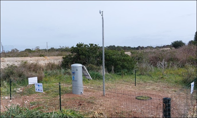

Evapotranspiration and unsaturated zone – The network also consists of 4 lysimeters for the continuous measurement of evapotranspiration, soil moisture and temperature, as well as for the quantification and chemical-isotopic characterization of infiltration waters passing through a known, undisturbed volume of soil.


Groundwater – The island features numerous Roman-style wells (PHOTO 1) that drain water from the surface aquifer, and four artesian wells that collect water circulating in the deeper conglomerate layers. Although now trickling and often inactive, the island also features a small spring, near which are the remains of ancient wash houses (PHOTO 2). Most of these wells have multiparameter probes installed (CTD-Diver, manufactured by Schlumberger) to monitor piezometric levels and physical-chemical parameters (electrical conductivity and water temperature).

Responsable
Matia Menichini
Contacts
matia.menichini@cnr.it
Related Staff
Linda Franceschi
Letizia Costanza
Andrea Berton
Marco Doveri
Roberto Giannecchini
Sandra Trifirò
Useful links
Hydrological and Hydrogeological Network Data
History of the network:
In 2014, as part of the PianosAquifer project, which aims to monitor the quantities and chemical, physical, and isotopic characteristics of the various components of the hydrological cycle, with particular reference to those that affect groundwater, the monitoring network of the hydrological and hydrogeological cycle of the Island of Pianosa was established. The initial network consisted of XXX divers and a totalizing rain gauge.
In 2018 , the first artisanal lysimeter was installed for the continuous monitoring of infiltration water and its cumulative monthly collection for subsequent chemical and isotopic analyses.
In 2022, as part of the CNR initiative to enhance instrumental infrastructure, the network was expanded with: a multiparameter weather station; a new precision lysimeter for continuous monitoring of evapotranspiration, soil moisture, and temperature at various depths, as well as for monthly monitoring of cumulative infiltration water in terms of quantity and chemical and isotopic characteristics; and additional multiparameter probes. Some of these probes were equipped with automatic data acquisition and transmission systems, forming, along with the lysimeter and weather station, the new remotely controlled hydrological cycle monitoring network for the Island of Pianosa.
In 2025, within the framework of the PNRR ITINERIS project (Correct reference to the project), 2 more lysimeters were installed for the continuous monitoring of evapotranspiration, soil temperature and humidity at different depths, as well as for the monthly monitoring of infiltration water in terms of quantity and chemical and isotopic characteristics.